I've had a lot of people ask me for pictures and comments from my trip to Denali. Since it's hard to pick out only a few pictures, and because I don't want to send around e-mails with 50 mega-bites of attachments, I thought it would be easier to just put it all into this blog so that everyone can look through it at their leisure.

I've also just returned from a few days in Yosemite (by way of Sonoma), so I added some pictures and comments from that little excursion as well.

Pay no attention to the dates here. It appears that blogs only post entries from the most recent to the oldest (who knew?). I wanted this to read from the start of my trip to the end, so I just assigned dates to each post to accoplish that. Also, please read the side-bar on how to enlarge the pictures.

Now that it's done, it looks like I've written quite a bit. Please don't feel like you have to read any of it, just enjoy the pictures if you want. And, of course, if you want any additional information on either of these ventures, please feel free to send me an e-mail at ctorrence1@cox.net.

Thursday, July 7, 2011

You're going where?

I got a notice from American Airlines stating that some of my frequent flier miles were about to expire, so where do I go?  Because it was the middle of the summer travel season, I didn't have enough miles to get to an international destination and  I couldn't come up with a compelling destination in the lower-48 states.  I liked the idea of seeing Denali, and had never been to Alaska, but I didn't know anyone that would really like to go camping up there, or that could go on such short notice.  Oh well, I tend to do pretty well on my own anyway, so off I went.

I booked my freebie flight in and out of Anchorage, bought a train ticket up to Denali, then another train ticket to go further up to Fairbanks.  I reserved a campsite at Denali, hotels in both Anchorage and Fairbanks, and finally, I booked a flight from Fairbanks back down to Anchorage so I could make my return flight home.  It's about a 12-hour train-ride from Fairbanks to Anchorage vs. a 1-hour flight, and the cost is about the same.  Since I'd have already covered those same tracks on the way up, I decided to save a little time on the way back.  I made several trips to the local REI store for some necessary equipment, and left Newport Beach with the 60-liter backpack from my South American adventure and another duffellbag stuffed with 40 lbs. of camping gear.

The trip to Anchorage via Dallas took all day (the penalty for using frequent flyer miles), but was otherwise uneventful. I got in to Anchorage (pop. 250 k) at a bout 9:00 pm.  The skies were overcast and the place seemed no different than any other mid-sized town, except that it was still light outside when I left a restaurant/bar at around 11:30 pm. My train was leaving at  8:00 am the next morning, so I figured I'd just make it easy on myself, retire early, and get a good night's sleep.

Anchorage train station.

The first-class section of the train to Denali that day was already full when I booked my ticket, but I did get a first-class ticket for my second-leg from Denali to Fairbanks later on. The train had a total of only 8 or 10 cars. After the engines and the baggage car, there were two first-class passenger cars. Then, there was a bar/dining car, 3 regular "excursion-class" cars, and finally, 4 or 5 cruise-ship cars.


The cruise-ships actually own their own train-cars and just pay a fee to the railroad company for pulling them. This way, they get to control the reservations and concessions, and probably charge  their tourists a higher price for the ticket. The "excursion-class" section of the train was fine by me, and costs about half as much as first-class. The middle excursion-class car (below, built in the 1950's) had an upper-level observation section with dome windows.  It's open to everyone, and you can eat in the first-class dining area if there is availability.


Excursion-class observation deck

Denali is about 280 miles North of Anchorage, and the trip takes about 8 hours. With the slow, gentle motion of the train, big windows, and beautiful scenery, it's a pretty relaxing way to travel. They also have someone that points out interesting sights and provides a narration of what's going on around you.  I brought James Michener's novel Alaska and was able to make some pretty good progress on its 800 pages.

Wednesday, July 6, 2011

Arrival at Denali National Park

Denali National Park covers about 6 million acres. It's about the size of Massachusetts, or half the size of Switzerland. If you could explore 1,000 acres per day, it would take you almost 16 1/2 YEARS to see the whole park.  The Denali train station is right inside the park entrance, and only a couple hundred yards from the visitors center.

Denali train station

After checking in at the visitors center, I hopped on a shuttle-bus to the Riley Creek campground - very conveninet since the campground is about a half-mile away, and I was lugging around 80 lbs of stuff.

Visitors Center


Within all of Denali's 6 million acres, there are only about 275 established campsites in 7 different campgrounds.  About 150 of the park's campsites are at Riley Creek.

Riley Creek, about 100 yds from my campsite

Most of the Riley Creek sites are set up for RV's, but about a quarter of them are "tent only" - which is where I'm staying.   I chose to reserve my campsite at Riley Creek, figuring that since I'm by myself, there'd be less chance of being eaten by a grizzly if I were sleeping among a larger group of people. I also thought that, if  I wanted to, I could move to one of the more remote "walk-up" campgrounds later in the week.


My campsite
 

Each campsite has a bear-proof food locker, and unless you're actually in the processs of cooking and/or eating, all of your stuff is supposed to remain in the locker. There's also a fire-pit, and you're allowed to pick up fallen wood around the campground. After seeing the sign in the picture below, I was a little concerned that my food locker was only about 30 feet from my tent. More alarming, though, was that as I was looking around for firewood, I found a huge pile of fresh anamal "skat" about 10 feet from my tent. Turns out that it came from a moose, however, and not a bear.  For some reason, that made me feel better.


Sign between my campground and visitors center

Also close to the Riley Creek campground is the Wilderness Access Center, or "WAC", which is the trasportation hub of the park. Outside of this area immediately inside the main gate, there is only one 90-mile road that goes into the park. The rest is all wilderness, and there are no maintained trails.  The first 15 miles of the road are paved, then it turns to gravel. At that point, there's a gate and a ranger station, and the road is no longer open to public traffic - to use it and go further into the park, you have be on a shuttle-bus from the WAC.

The smaller campgrounds are all located out along the park road at distances ranging from 13 miles to 85 miles from the entrance. Some of the sites can be reserved in advance while others are only available to "walk-ups". The two smallest campgrounds have only 7 campsites each, and no improvements, such as toilets or running water. Wilderness, or backcountry camping is also allowed, and I'll describe that a little later.

Tuesday, July 5, 2011

Disco Hikes

They're not what you think.

So, you get on a shuttle-bus to go deeper into the park.  You're welcome to get off the but at any point along the road, stay as long a you like, and go wherever you want.  You just ask the driver to stop and let you off.  Then, whenever you're ready, you can get on the next bus going either direction, and continue your journey.  With no existing trails, however, it seems that very few people actually go out onto the tundra.  One of the bus drivers told us that  probably 90% of the people that take a shuttle into the park never even leave the side of the road.  Without the Discovery Hikes, or "Disco Hikes", I probably would have fallen into that vast majority.

For a fee of $32.00, the park offers a handful of Disco Hikes each day.  Each hike is led by a park ranger, and is limited to 11 people on a first-come/first-served basis.  There are different degrees of difficulty and distances covered, so, you get to pick your poision, and you have to bring all of your own food and water for the day.  I chose a 5-mile round-trip hike to the top of Cathedral Mountain, which has an elevation gain of about 2,000 feet.  It was labled as a "strenuous" 6-hour hike, which I now think was a bit kind.


Starting point for our climb


We had 7 people in our group, including Ranger Michael, who has been with the park for about 20 years.  Our shuttle left the WAC at 8:00 am, and at about mile-34, Michael told the bus-driver that this would be a fine spot for us get out.  So the driver pulled to a stop, let us out, and then drove on down the road.  Without hesitation, Michael said "let's go in for a few hundred yards, then we'll stop and go over our plan for the day".


I've never walked on tundra before.   We started out on what is called "wet" tundra.  For the most part, the tundra is just open land that's covered in several inches of low-rising shrubbery, ferns, moss, and liechen.  From a distance, it doesn't look any different than a typical pasture or meadow.  But it's very thick, kind of springy, and walking on it feels like you're walking on a lumpy mattress.  Very different that anything I've hiked on before.  Where we left the road, every footstep sank about 6 to 8 inches into the stuff.  The layer of tundra acts as insulation over the perma-frost.  During the summer, the very top of the perma-frost warms up, turns to muck, and there you have your "wet" tundra.  It's not easy to hike through.

A level picture to show the grade

Once we stopped, the first thing that Ranger Mike said was, "statistically speaking, we shouldn't encounter a bear".  In Denali, a bear has never engaged a group of 6 or more people, probably because the group just makes too much noise.  Smaller groups, especially 1's and 2's, generally don't make enough noise, and can suprise a bear, which is obviously not good.  But, nobody has ever been killed by a bear in the park, and they attribute that to certain practices that I'll describe later.  Nonetheless, Ranger Mike emptied his back-pack, showed us his first-aid kit, and how to work his radio and satellite phone in the event he became "incapacitaed".  He also asked if anyone had any medical training.  Nice.

Ranger Mike said that every time they do a Disco Hike, they try to make sure that they don't go to the same place twice in the same season, or, at least never use the same route twice.  So, while he knows where we're going, this is going to be a new hike for him also, and there's a pretty fair chance that our route is going to cover some land that's never been walked on before.  After a radio-check with the ranger station confirming our entry point, destination, and the number of people in our group, we started our way up the base of the mountian.


The summit of Cathedrial Mountian is at 4,905 feet, and the base of the valley where we began is at about 3,000 feet.  So, it's just short of 2,000 feet of elevation gain.  The slope is reasonable at first, and while walking across the open tundra, we are istructed to separate and NOT follow each other so that we don't even begin to create a trail.  When we get to the thicker brush and 8 to 10-foot willow trees, we all come together and start following the existing game trails - trails that have been created by the forraging moose and bear - first, because it's easier and second, because we still don't want to create new trails.  Here, where we can't see much more than what's right in front of us, we start calling out "hey bear" or "hey moose" every 15 or 20 seconds, just to make sure that we don't surprise someone.

We came across both moose-skat and bear-skat on the game trails, and it's important to be able to know one from the other, and recognize how old it is.  It's good to know whether it came from a moose last week, or a bear last night.  We found two-week-old bear-skat that contained a partially digested rabbit foot at one spot, and fresh moose-skat at another.  If the bear-skat was as fresh as the moose-skat, Ranger Mike said that he would have been just a little bit nervous.

Ascending above the heaver brush, we entered onto the "alpine" tundra.  It's much thinner than the wet tundra, so you don't sink-in as much and it's a lot easier to walk through.  And here, we came upon a "bear dig" (below).  Ranger Mike said that a bear will chase a burrowing animal into its hole, then just use its brute strenght and sharp claws to rip up the earth until he finds his lunch.  He examined the dig and estimated that this was probably once home to the rabbit who's foot we found in the bear-skat below.  Tough way to go, huh?

 
A "bear dig"

The picture below is looking the other direction from the bear dig.  If you knew what to look for, you could see Mt. Healy, just left of center and behind the green mountians in the foreground.  It's 34 miles away, where Camp Riley and the park entrance are located.  Not a bad spot for a bear to have some lunch.


About half way up, we found a flat spot, and stopped to have lunch ourselves.


Lunch spot


The mountain in the picture below is across the valley and about 3 miles away from where we stopped for our break  Near the top left is a small herd of Dall Sheep (little white specks, if you enlarge the picture - there's a long fang-like shadow on the mountain, left of center, and the sheep are in the smaller dark shadow right above that).  These sure-footed creatures live at the top of the mountain peaks to avoid preditors, but eagles have been know to make a meal out of them by crashing into them and causing them to fall to their death.  Kind of makes you wonder if it's better to be a Dall Sheep or a rabbit.  We saw several golden eagles there in the park, and I saw one bald eagle on the train to Fairbanks.

Dall Sheep on the mtn. across from our lunch spot

The last several hundred feet of the climb were incredibly steep.  This is Ranger Mike, and you can just make out another hiker coming up behind him.  All you can see is the top of his head, which is below him and to the left.  Like I said, it's really steep.


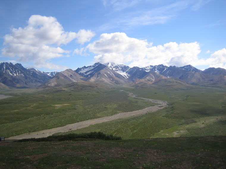
The view from the top was spectacular.  Note the shuttle bus down on the road in the bottom right of the picture below.

Northern view from top of Cathedral Mtn.


Western view towards Mt. McKinley

Southern view towards Anchorage


In the picture above, I'm back down at our lunch spot, and looking up toward the top of Cathedral Mtn.  If you enlarge the picture, you can probably see a few of the other hikers who are still on their way down.  They're in the center near the top.  The slope is so steep that you have to serpentine all the way up and down.

The beauty of the Disco Hike is that it gets you out into the wild.  I probably would not have attempted something like this on my own, but having a ranger lead a small group is a perfect combination that lets you take on this challenging kind of hike safely.  I learned so much from Ranger Mike on this trip that I started thinking about  going out into the wilderness on my own.  I quickly realized, however, that at least on this trip, I was lugging around way too much unnecessary stuff (like a folding chair, a big air mattress, too many clothes, etc.).  And to top it off, my tent was way to big to take down, re-pack, lug around all day, and set up again every evening.  So, I started a new list for my next trip to REI store.


I think that I was out in the park for about 12 hours on this day.  Of course, just because you're out in the wilderness doesn't mean that you can't have a decent meal.  I treated myself to this nice salmon dinner at the park grill after the hike.  The restaurant is located next to the visitor's center.

A just reward after a long day

The Park Grill

Other than eating at the grill, there's a small convenience store at the campground where I could buy some groceries - canned soup, chili, jerkey, trail mix, etc.  One of the coolest gadgets that I bought at REI is this green "Jet Boil" stove system.  The whole system, including fuel, packs down into the cooking vessel (very bottom picture, and note the sunglasses and 1-liter water bottle for scale).  It starts with a spark-switch, so you don't even need a match, and it will boil water in about 2 minutes.  I started most days with a cup of that Starbucks "Via" freeze-dried coffee, and would then heat up a can of chili for breakfast. I could do the whole meal, start to finish, in about 15 minutes, and then be ready to hit the trail.


My new stove - perfect for wilderness camping

Wilderness camping is allowed in Denali, or perhaps I should say that it is even encouraged.  Basic rules are that you pack everything in AND out (including used toilet paper), no fires (but camp stoves are OK), no guns, your campsite cannot be visible from the park road, and you should not use a campsite that was previously made by someone else.  You have to check in at the WAC, get a backcountry permit, file a plan and then discuss it with the rangers, and they will lend you a bear-proof food container.  The park is divided into about 90 units of various sizes, and they tightly control the number of campers that are allowed in any unit at any one time.  They allow only 2 or sometimes 4 wilderness campers in the smaller units (40,000 to 50,000 acres per unit) and maybe 10 to 12 campers in the larger units (80,000 to 90,000 acres per unit).  So, chances are that once you leave the road, you and you're group are not going to see another person until you return.


Monday, July 4, 2011

Wonder Lake and Mt. McKinley

Wonder Lake is near the end of the park's 90-mile gravel road.  The lake is about 25 miles from the base of Mt. McKinley, the tallest peak in North America, and it's as close to the mountain as you can get via the park transportation system.  If you want to see McKinley, you pretty much have to make this trip.  Round-trip on the shuttle takes about 13 hours, and the bus leaves from the WAC at 6:15 am.  That's right - it LEAVES at 6:15 am.  And, the WAC is a half-mile hike from my campground.

 
The night before, I figured that I'd just work on that Michener novel until it got dark.  It's a great book, so I got caught-up in it, and before I knew it, it was 1:30 am and I was still reading by daylight.  So, when the alarm on my watch went off at 4:30 am, I knew that this was going to be a long day.   It was still light outside, and to top if off, it was raining.


The mountain is only even partially visible on about 1 out of every 4 or 5 days - so, 75% of the visitors never even get a chance to see it.  It's so massive, that it creates its own weather system, and it's generally shrouded in clouds.  There are only a handful of "post card" days each year when you get a cloudless view of the mountain.  Given the rain, I was pretty sure that today was going to be one of those cloudy days when you couldn't see the mountain, so I came pretty close to just blowing this one off.  Ultimately, however, I decided that if I'm only goint to be here once, sleep or no sleep, I'd better make the best of evey opportunity that I had, so at 5:30 am, I sucked it up and started hiking off to the WAC.

One on the bus, the first 35 miles was a rather boring repeat of yesterday, but then it got interesting.  We started to see lots of caribu, moose and Dall Sheep.  I can see them all up-close and personal with my binoculars, but they're pretty far away, and won't make very good wildlife pictures.  The bus driver said that a lot of visitors are really disappointed in the wildlife views.  They expect there to be big herds of animals right next to the road, and it's just not like that.  Then, we came upon these grizzly bears - a mother and her two cubs, about 100 yards from the road.


I mentioned earlier that nobody has ever been killed by a grizzly in Denali.  By tightly controlling public access, and by requiring the use of bear-proof food storage devices in both the campgrounds and the backcountry units, they have managed to kept the bears from associating humans with food.  The bears certainly know that we humans are there - they can smell us from miles away.  But we don't smell like food to them, or at least what they know is food, and we don't leave behind anything that turns out to be food for them.  So, the bears are just not that interested in us.  And they'd rather be alone anyway, so when we make enough noise that they can hear us coming, they generally leave the area.  Compare that to someone at Yellowstone that throws a ham sandwich to a bear from their car.  Once that happens a couple of times, the bear starts to beleive that all cars dispense ham sandwiches, and you get the picture.  Of course, if you're out on a hike and startle a mother with a couple of small cubs, you've got a whole different situation on your hands.  That's why we say "hey bear" every 15 or 20 seconds when we're in the brush.

View from Polychrome Pass

 
Polychrome takes its name from all of the bright colors of the minerals that make up the mountains in this area.  It's about 45 miles into the park. 

Eielson Visitors Center

The picture above was taken at the Eielson visitors center, which is a little more than 60 miles into the park and about 30 miles from Mt. McKinley.  We're looking right at the mountain.  Or, at least where the mountian should be.  This is the typical cloud covered view that most visitors get.  The peaks of the mountains that you can see here top-out at around 5,000 feet, and the big guy is behind this range.

Wonder Lake


Wonder Lake is about 4 miles long, and very remote and beautiful.  There's campground here that has 28 tent-only sites, flush toilets, and running water.  I considered trying to staying at this campground, but, you're 85 miles from the main entrance of the park, the convenience store, and the showers, and the only way to get here is by the shuttle bus.

Mt. McKinley

Though it stopped raining pretty early, it remained overcast most of the day.  Right as we started back from Wonder Lake, however, the clouds lifted for about 5 minutes, and there was Mt. McKinley.  Not a full-on view, but a pretty amazing site nonetheless.  McKinely has the largest relief on any point on Earth.  With the peak at an elevation of 20,320 feet and it's base at 1,000 to 3,000 feet, it has a relief of 17,000 to 19,000 feet.  In contrast, Everest tops out at 29,029 feet, but its base ranges from 14,000 to 17,000 feet, so it has a relief that is only about 3/4 of McKinely's.

Mt. McKinley

Mt. McKinley was named after the 25th president of the United States in the 1890's, even thoug he never stepped foot in the state.  McKinley was assassinated in Buffalo in 1901.  For thousands of years before that, the mountian was known to the Athabaskan Indians as Denali, or "the high one".  That's what the locals still call it, and I think it makes more sense.  Several attempts to officially change the name back to Denali have been blocked by congressmen from Ohio, McKinley's home state.

The mountain was first climbed in 1913, and about 100 people have died trying to climb it - most have died on their way back down after reaching the top.  They say that it's not particularly hard to climb (a 74-year-old lady has done it), but that since it's so close to the Arctic Circle, you can quickly find yourself in 100 to 150 mph winds, and temperatures can drop to -75 to -100 degrees.  Yikes!

Sunday, July 3, 2011

Mt. Healy

On my last day in the park, I climbed Mt. Healy. It's near the entrance, so no need for the shuttle-bus, and it has a maintained trail, so it can't be that hard. Right? Of course not. This one was brutal.

I packed all my gear early in the morning and checked it into the train station, but still had about 5 hours before my departure. For some reason, I had it in my mind that the base of Healy was at about the same elevation as the base of Cathedral Mt. So, I thought I'd be doing about the same elevation gain (+/-), but over a shorter distance.  All I was really concerned with, however, was just making it down in time catch my train.  I'd be pretty screwed if I missed it and the train took off with all my stuff.

Half-way up Mt. Healy

 
About half way up the mountian, I start watching the clock, and it doesn't seem like I'm making much as much progress as  I should. 

3/4ths of the way up Mt. Healy


The views just keep getting better.  Almost to the top, and I figure that I'll have to descend about twice as fast as it took me to get up.  Two hours to get to the top, and one hour to get down.

From top of Mt. Healy


From the top of Mt. Healy (above), we're looking south towards the Alaskan Range, which runs East-West, and most of the peaks are +/- 5,000 feet. The views are stunning, but these pictures are a bit hazy because they were taken in the morning, and into the sun. If I had know better, I'd have come up here at the end of the day. 

 
Turns out that the peak of Mt. Healy is at 5,400 feet and the valley is about 1,600 feet. So that's almost 4,000 feet of elevation gain - nearly twice the elevation gain of Cathedral Mtn.  With the clock ticking, I had to essentially jog the whole way down to make the train in time. I was lucky to have gravity on my side and a maintained trial most of the way.

First-Class cars


As mentioned, I did buy a first-class ticket from Denali to Fairbanks.  The seating is up in the top of the car, and the first-class dining is on the bottom.  There is an open-air deck at the back of the seating area.  The first-class seating is a bit nicer than excursion-class, you have a cute bar-tender in the car and you're sitting higher, which improves the views, but I don't think that it's worth twice the price of the excursion-class.

Mama moose and he baby in lake


As the train left the park, we passed this lake (above), which has a mother moose and her baby taking a swim (top-center of the lake).  The picture below shows the Nenana River, which runs North, up the Eastern side of the park.  It's a popular for white-water rafting, but it's really cold (there's a raft near the middle of the picture).  Only a few days ago, this river water was part of a glacier, and is only a couple of degrees above freezing.

Saturday, July 2, 2011

Fairbanks

From what I had read about Fairbanks, it's much more typical of Alaskan frontier cities than Anchorage, so I thought I'd spend a few days there.  With a population of only 35,000 people, it's the second largest city in the state, and believe it or not, it's named after a Hoosier!  Turns out there was a Senator Fairbanks from Indiana, who was also the Vice President during Teddy Roosevelt's second term.  Like McKinley, Vice-President Fairbanks never stepped a single foot in Alaska.  These naming honors were done simply to curry favor from the politicians.


The city was founded in 1901 by a guy named E.T. Barnette.  He wanted to establish a trading post in the Northern part of Alaska to take advantage of the gold-rush, and hired a paddle-wheeler to take him and his supplies as far North as the boat could go.  Well, they ran aground here, 125 miles from the Arctic Circle (about 1,800 miles from the North Pole), and there you have it.  The average high temperature in January is 0 degrees, and they get about 3 1/2 hours of sunlight per day in the winter.  Maybe that's why they have a tendancy to drink!


Of course, it's the opposite in the summer, and I was happy to have a hotel with black-out curtains.  There happened to be a BBQ joint next to my hotel that had been featured on "Diners, Drive-Inns, and Dives".  I had some excellent ribs and a few beers while listening to a pretty good local band.  The weird part was that when I left at 12:30 am, it wasn't just light, I could still SEE the Sun.

Pioneer Park

I went to Pioneer Park the next day, where they have re-located a large number of original buildings from the city's earliest days (most appeared to be whorehouses at one time or another).  One of the best meals I had was at a "restaurant" here called the Salmon Bake.  It is essentially, an outdoor section of the park with tables and chairs surrounded by old mining equipment.  It's all-you-can-eat salmon, crab legs, prime rib, and fried fish.  They also offered things like salad and vegetables, but I skipped all that stuff and just focused on high-value items.  And dessert.

Mt. McKinley

On the flight back to Anchorage, I was fortunate to have a right-side window-seat, and this allowed for one final look at Denali.  From this view, I believe that that is Ruth Glacier near the bottom.  The balck lines in the middle are called a medial moraine.  As two glaciers come together further up the mountian, the rock and debris that each edge scours off the mountain piles up in the middle of the new glacier as the two become one.  Ruth Glacier is a mile wide, 10 miles long, and 3,800 feet thick.  It drops 2,000 feet from top to bottom and is said to flow down-hill at a rate of 3 feet per day.  Imagine the force behind that!

All in all, this was fabulous trip - if I said once in a lifetime, I'd hope that I'd be wrong about that.  The pictures here, as one might expect, can't begin to do justice to the scenic bueauty of this place, or in any way give you a feel for the vastness of the area.  If you ever have a chance to come here, don't miss it!

Friday, July 1, 2011

Todd-Fest and Yosemite

My rugby buddy Todd Phillips was killed in a motorcycle accident on March 31 of this year while he was on his way to a rugby game.  Todd-Fest was organized as a proper memorial for the rugby community, and to help establish a trust-fund for his 3-year old son Zealand.  The event was held up in Sonoma County, so I thought it was only fitting that I ride my Harley up to the event.  Figuring that I'd either explore the coast or some mountains on my way up or back, I bought a new, smaller tent, strapped it onto the bike, and headed North.  In Sonoma, we did wine tours on Friday, played a rugby match on Saturday, and had a banquet that night which was followed by a pub-crawl.  I did 1,400 miles over 6 days, and stopped at Yosemite for a few days on the way home.

Bridalveil Falls on the right. 620 feet high, and had lots of water flowing this year.
  The following week, three people got swept over a different falls and died.

I've been to Yosemite several times, but never in the middle of the summer.  No campsites were listed as "available" at the campground office when I arrived, but some people do leave early and others just don't show up.  They take names on a waiting-list every morning, and at 3:00 pm, they parcel out the unclaimed spaces.  But, you have to be there at 3:00 to win - they call your name twice, and if you don't answer they go right to the next name.

Looking across Yosemite Valley
at Columbia Rock.

It was about 10:00 am when I signed up, and I was number 24 on the list.  Since I had 5 hours, I decided to just cruise around and see what I could see.  If  I got a spot, I'd stay, and if not, I'd leave.  Well, it didn't take long before I confirmed for myself that summer is not the time to come here.  The place was overrun with cars and pudgy, loud people wearing Rainforest Cafe t-shirts.  Within a few hours I had almost decided that I didn't even want to stay here.  With the motorcycle, though, I can always find a place to park, and eventually, the scenic beauty calmed my nerves.

My bike, in front of El Capitan.

I'm really not parked in a handicap zone here. I slipped into a small gap between a parked car (which is now gone) and the blue line.  There's always room for motorcycle parking.

El Capitan seems to be everyone's favorite for climbing.  The sheer face is about 3,000 feet from top to bottom, and the first ascent took place until 1958.  It took a team of  4 climbers 47 days to do it!  Today, fit climbers have a 60% success rate and get it done in 4 to 5 days.  The record, however, is just over 2 1/2 hours, and some people have done it more than once a 24 hour period.  If you enlarge the picture below, you may be able to see the climber in this picture.  About a third of the way up, in the middle of the picture, there's a shadow that looks like a "7".  If you start at about a third of the way up from the bottom of the "7", and move left to the next vertical shadow, there he is - that little dot.  Or, maybe it's a she.  Either way, the climber still has a bit of work to do.


At 3:00, I was part of a suprisingly large crowd that had gathered outside the campground office.  A ranger came out and said that they had 16 spaces to allocate.  I knew that I was number 24 on the list, but there had to be at least 50 people in the crowd.  Luckily, enough people infront of me didn't show and I was the next to last person to get a spot for the night.  The campground was circus-like, but by now I had already conceeded that, while on family camping trips so many years ago, my brothers and I had surely offended more people than were currently offending me, so it was all OK.

My new tent from REI.
Packs small, and weighs less than 5 lbs.


On the way to Half Dome, you hike by Mirror Lake.  I can't remember the name of this formaiton, but it makes up the other side of the valley across from Half Dome.  A glacier slid through this valley and carved the sheer face of Half Dome.  Think about the Ruth Glacier example above, a mile wide, 3,800 feet thick, 10 miles long, and moving at 3 feet per day - that will scrub out a lot of rock.
Half Dome.
The peak is about 4,800 feet above where I'm standing.

Inspiration Point

This picture is taken from Inspiration Point.  El Capitan is on the left, Half Dome is in the middle, and Bridalveil Falls is on the right.  In person, it looks absolutely surreal.  Unfortunately, from here on out, I've got something on my camera lens.

Half Dome from Glacier Point

This is Half Dome, as seen from Glacier Point.  In all my trips to Yosemite, I never made it up here before.  But I have to say that this is probably one of the most spectacular views in the World.  Glacier Point is directly on top of Curry Village and most of the campgrounds, and there are two ways to get here.  Either a challenging 6 to 8-hour hike with 3,200 feet of elevation gain, or a 35-mile drive.  The road, however, is closed for 7 months of the year, and there is still snow up here, even in July.  The top of Half Dome is at an elevation of 8,800 feet, but some of the peaks on the horizon behind it are over 13,000 feet.  You can climb to the top of Half Dome from the back.  It's strenuous, but not technicaly challenging.  There's a set of cable rails to help you get over the steep hump.  I've done it on previous trips, but now you need a permit, and figured that it would be too much of a hassle to try and do it this time.  It's obviously slippery when wet, and I read that someone fell about 600 feet to their death just the other day.  About 60 people have killed themselves on or around Half Dome.

Curry Village from Glacier Point

The picture above is also from Glacier Point, looking  straight down on Curry Village and the some of the surrounding campgrounds.  It's a sheer drop of about 3,200 feet.  That little circle is actually a parking lot with about 150 cars in it.

Yosemite Falls from Glacier Point

Looking across the valley from Glacier Point to Yosemite Falls.  Yosemite Falls is over 2,400 feet high in three stages.  It's the highest waterfall in North America, and the 7th highest in the Word.  Yosemite has 8 different waterfalls that are over 1,000 feet high (4 of them are over 1,500 ft).  There was a huge snowfall this past winter, and the melt has made this one of the best waterfall seasons in years.


Comparing Denali to Yosemite?

It's apples and oranges.    Stunning beauty in both, but different kinds of beauty.  Both are vast, but in different dimensions. Denali is hard to get to, so you really have to want to go there.  But you'll be rewarded with a feeling that you almost have the place all to yourself.  Yosemite is closer and more compact (at least in the popular valley area), but you have to compete with the rest of civilization to see it.  They're both awesome though.